SeaSketch 2.0

SeaSketch 2.0 is here! Previously codenamed “SeaSketch Next”, the new, free and open source platform is now accessible at www.seasketch.org. All projects hosted in the previous version can still be accessed via legacy.seasketch.org.

The latest version is a complete re-write of the application, using free and open source technologies from the ground up. Users will notice significant performance enhancements in map rendering and in generating reports. There are also a number of new features including:

  • An open geoprocessing framework for developers to create their own analytics and reports.

  • Data hosting and cartography tools for project administrators. You can now upload datasets directly into SeaSketch and use our cartography tools to style your data.

  • Improved map bookmarking in forums. Forum messages can contain one or more map bookmarks which record the map state, including extent and active data layers. Moreover, the bookmarks store an image of the map in the SeaSketch database so that if the underlying data layers change, you will have a record of how the map looked when bookmarked.

  • Offline capabilities for surveys allow facilitators to work in areas with little or no Internet connectivity.

  • Support for tablet and mobile devices.

  • A dramatically improved survey tool builder. With new forms and attributes, combined with support for mobile and tablet devices, the survey tool stands to be the most powerful survey tool build specifically to support marine spatial planning.

Go ahead and create your own SeaSketch project today! Follow this link to create your project and be sure to reference our help documents to get started.

Will McClintock

Dr. Will McClintock is a Project Scientist at the University of California Santa Barbara and former Director of the MarineMap Consortium. He received a B.A. in Biology from Earlham College, M.S. in Behavioral Ecology from the University of Cincinnati, an M.A. in Counseling Psychology from Pacifica Graduate Institute and a Ph.D. in Ecology, Evolution and Marine Biology from the University of California Santa Barbara. He has participated in over a dozen marine spatial planning initiatives around the world.

International Participation in a National MSP Initiative

The Caribbean island of Montserrat initiated a comprehensive marine spatial planning process in early 2016. Project partners include the Montserrat Government, the Waitt Institute and contractors, including the McClintock Lab (SeaSketch) and the Sustainable Fisheries Group at UCSB. These partners support the Blue Halo Steering Committee which is comprised of approximately 20 representatives from various stakeholder groups including recreational and commercial fishers, tourism, diving, conservation, science, and enforcement.

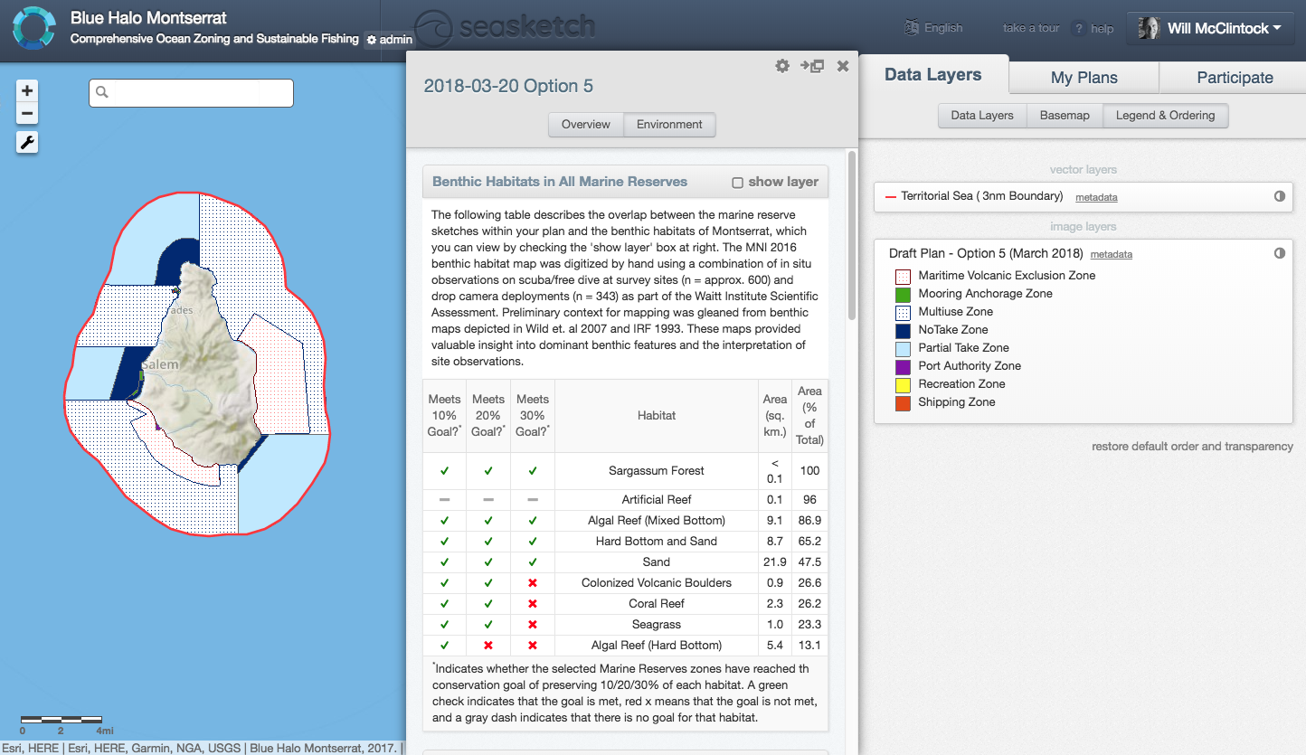
Since May, 2017, Steering Committee members have been drafting proposals for a suite of ocean zones that would span the entire 0-3 nautical mile jurisdictional area around Montserrat. Prospective zones include partial-take and no-take marine protected areas (“sanctuaries”), mooring and anchorage zones, recreation zones, shipping areas, multi-use zones (i.e., status quo), and maritime volcanic exclusion zones.

The Blue Halo Montserrat Steering Committee meets on April 10, 2017, to discuss ocean zoning options. Here, a stakeholder presents a zoning concept drafted in SeaSketch.

The Blue Halo Montserrat Steering Committee meets on April 10, 2017, to discuss ocean zoning options. Here, a stakeholder presents a zoning concept drafted in SeaSketch.

One key design goal is to designate at least 10-30% of Montserrat’s near-shore environment within no-take MPAs to protect ocean habitats and replenish fisheries. Using SeaSketch, Steering Committee members used maps of benthic habitats, dive and fishing value, IUCN Listed Corals, and a conservation priority layer, to sketch and evaluate prospective zones. And, in March, 2018, the Steering Committee requested public comment on a comprehensive zoning plan that met the 10-30% protection goal for most habitats, falling slightly short for Colonized Volcanic Boulders, Coral Reefs, Seagrass and Hard Bottom Algal Reefs.

A draft zoning proposal (Option 5) developed by the Steering Committee in March, 2018.

A draft zoning proposal (Option 5) developed by the Steering Committee in March, 2018.

On June 19, 2018, something quite interesting happened. The Steering Committee met to discuss comments that had been received from the general public regarding the latest zoning proposal. Some of the criticisms were articulated by a journalist for Discover Montserrat in an article entitled “Is the Marine Spatial Plan a Lose-Lose for Montserrat?” in which the author, Narissa Golden, expressed concern that the latest zoning proposal had only allocated 6% of the area in no-take marine protected areas.

Simultaneously, on a Portuguese island over 2,600 miles away, masters students studying marine spatial planning (MSP) were using SeaSketch in attempt to help the Steering Committee address these criticisms. The Erasmus Mundus Masters Course on Marine Spatial Planning included lectures and a SeaSketch workshop where, rather than simply studying MSP, students were asked to actively participate by studying the Blue Halo Montserrat planning process, evaluating proposals developed by the Steering Committee and providing one or more options that would help improve zoning proposals based on objectives defined by the stakeholders in Montserrat.

Masters students in the Azores, Portugal, work collaboratively in SeaSketch to refine a zoning proposal developed by the Blue Halo Montserrat Steering Committee. June, 2018.

Masters students in the Azores, Portugal, work collaboratively in SeaSketch to refine a zoning proposal developed by the Blue Halo Montserrat Steering Committee. June, 2018.

By studying maps depicting the distribution of valued fishing grounds and benthic habitats, the masters students developed a modified version of the Steering Committee’s Northern No-Take Zone shown above. Using a public forum in SeaSketch, students proposed their zone concept along with an explanation for how their design would double protections for coral habitat and increase Hard Bottom Algal Reef protections by another 12.5 square kilometers to meet planning guidelines. Furthermore, their plan would boost the amount of no-take marine protected areas to slightly over 10% of the study area.

A zone proposal developed by a group of masters students which is a modified version of one developed by the Steering Committee.

A zone proposal developed by a group of masters students which is a modified version of one developed by the Steering Committee.

The Blue Halo Montserrat Steering Committee is currently deliberating this proposal alongside other ideas developed by the committee and members of the general public. It remains to be seen whether the student proposal is incorporated into the final zoning plan but, regardless, their work suggests several important ideas. First, sometimes good ideas can come from unexpected sources - including students from other countries, thousands of miles away. Second, the web-based decision support platform, SeaSketch, facilitated real-time participation in a transparent, science-based and stakeholder-driven process. While the Erasmus Mundus students could not have traveled all the way from the Azores to Montserrat to participate in the MSP initiative in person, they could jump on the Internet and participate via SeaSketch.

Good ideas can come from unexpected places. Students in the azores suggested modified zoning designs to stakeholders in montserrat.

Good ideas can come from unexpected places. Students in the azores suggested modified zoning designs to stakeholders in montserrat.

To view the latest zoning proposals or the experiment with sketching and evaluating zones in SeaSketch, visit http://montserrat.seasketch.org. To read more about the Blue Halo Montserrat initiative, visit their website.


1 Comment

Will McClintock

Dr. Will McClintock is a Project Scientist at the University of California Santa Barbara and former Director of the MarineMap Consortium. He received a B.A. in Biology from Earlham College, M.S. in Behavioral Ecology from the University of Cincinnati, an M.A. in Counseling Psychology from Pacifica Graduate Institute and a Ph.D. in Ecology, Evolution and Marine Biology from the University of California Santa Barbara. He has participated in over a dozen marine spatial planning initiatives around the world.

Azores Travel Blog: Dr. McClintock Leads Erasmus Mundus Masters Course in MSP

I spent the first week of May, 2017, in Ponta Delgada on the Island of São Miguel in the Azores. These Portuguese islands begin 850 miles off the mainland in the middle of the Atlantic Ocean and are – to visitors and residents alike – among the most beautiful places on earth.  The 16 students in the Erasmus Mundus cohort, from Italy, Brazil, Lebanon, Greece, Trinidad and Tobago, Yemen, Philippines, United States, Ethiopia, Ghana, Costa Rica and Bangladesh, represent the most diverse group I’ve ever worked or studied with. With educational and professional backgrounds ranging from marine biology and oceanography, architecture, planning, geography, these students are completing their first year of a two-year master's program in maritime spatial planning. Helena Colado & Catarina Fonseca led the course, and invited myself, Jacek Zaucha, and Kira Gee as guest lecturers for this segment.

After receiving lectures on lessons learned from MSP in Poland, Germany and the Caribbean, including issues pertaining to stakeholder engagement, incorporating culture values, students spent the majority of the week developing a maritime spatial plan for the islands of São Miguel and Santa Maria. The class was divided into 4 groups of 4-5 students, each with their own SeaSketch project. With an introduction to the survey tools, administrative interface, geodesign and discussion forum features in SeaSketch, students were encouraged to configure their SeaSketch projects to reflect the needs of their specific plan. As the goals and objectives of each plan was fleshed out, students added data from existing map services they discovered from a variety of sources, and created new map services from data derived from shapefiles and rasters. One group devised a survey tool for gathering fishing values data from fishermen.

From the technical perspective, students quickly learned that SeaSketch shines as an easy-to-use method of gathering information from stakeholders, as a collaborative design tool and as a discussion tool during the development of the process itself. Looking through their discussion forums, for example, I could see some groups made good use of the forums as a means of sharing map data and views, and coordinating their efforts to gather information. Several students also discovered that it is not (as some may have assumed) a replacement for a desktop GIS.  As future planners, their understanding of geospatial data formats, projections, analysis and cartography will be essential as a technical foundation.

I will be interested to see who takes up SeaSketch to facilitate their work after graduation next year. One student expressed an interest in translating the user interface into Arabic this summer. That gives me hope that SeaSketch will begin to see more use throughout the Middle East.

How to Support the West Coast Regional Planning Body with SeaSketch

On October 26 & 27, 2016, the West Coast Regional Planning Body (WCRPB) met to discuss how it might support and harmonize sub-regional marine spatial planning efforts. Interestingly, the WCRPB will not be planning in the traditional sense (i.e., drawing lines on maps). Rather, they will work to support sub-regional planning efforts to ensure that they use the best-available science, understand the tradeoffs and consequences of options as they are developed, and that they are transparent and properly facilitated. 

John Hansen, marine planning coordinator, addresses attendees at the west coast regional planning body meeting, Portland, OR. The WCRPB is seated behind him. 

Along those lines, Andy Lanier, Steve Steinbeck and Allison Bailey reviewed the West Coast Ocean Data Portal, a platform for discovering geospatial information relevant to West Coast planning efforts. The WCRPB members agreed that sub-regional planning groups could use the data exposed in the Data Portal (and other sources) to develop new models and analyze the value and consequences of prospective pans. 

As a first step, I'd like to see sub-regions use SeaSketch to visualize data from the portal and use the discussion forums to generate ideas on what datasets are useful, which need improvement and where there are data gaps. For example, as marine spatial planning begins to take shape in San Diego, planners can import data found in the West Coast Ocean Data Portal, and stakeholders can inspect them and talk about whether they are appropriate for planning purposes. 

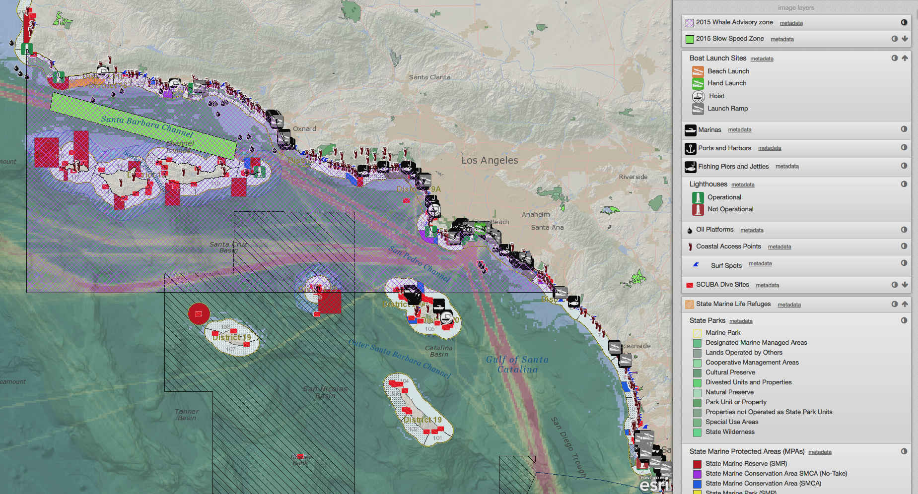
Discussing a data layer (marine protected areas) in a demonstration project for San Diego marine spatial planning (sandiego.seasketch.org). 

Discussing a data layer (marine protected areas) in a demonstration project for San Diego marine spatial planning (sandiego.seasketch.org). 

Each sub-region will have different planning goals and objectives. Some areas may focus on aquaculture development, commercial shipping and military uses, while others may focus on renewable energy, conservation and fishing. The specific goals and objectives will determine how plans will be evaluated by sub-regional planning bodies. 

If SeaSketch is used to sketch evaluate proposed marine spatial plans, we could use tradeoff models in combination with geodesign principles that allow users to sketch any prospective plan (e.g., aquaculture sites, renewable energy sites, fishing zones) and evaluate its relative value. 

Evaluating tradeoffs for marine spatial plans for Montserrat (montserrat.seasketch.org). 

Evaluating tradeoffs for marine spatial plans for Montserrat (montserrat.seasketch.org). 

As sub-regional planning moves forward independently throughout the West Coast, the WCRPB might consider evaluating sub-regional plans within the regional context and provide sub-regional planning bodies with useful feedback before plans are submitted to the National Ocean Council for approval. That is, the WCRPB may not be developing plans per se, but they could use SeaSketch to evaluate the sub-regional plans using, say, a cumulative impact analysis. 

A regional cumulative impact model has already been created by Halpern et al (2009) though perhaps it could be updated. That's easy enough. Once the models are freshened up, they can be imported into SeaSketch. The WCRPB members could then accept any plans developed by sub-regions and calculate how they may increase or decrease impacts to ecosystems in the California Current. 

We have already provided WWF-Canada for this kind of tool to be used when stakeholders develop plans in British Columbia.

Evaluating cumulative effects of human activities in British Columbia (cebc.seasketch.org). 

So, what needs to happen? Our vision is for the WCRPB to make SeaSketch available to any sub-region within the West Coast planning region. Then, the WCRPB will support the science to update the California Current Cumulative Impact models and the implementation the above described sketching and evaluation tools for the West Coast. 

Will McClintock

Dr. Will McClintock is a Project Scientist at the University of California Santa Barbara and former Director of the MarineMap Consortium. He received a B.A. in Biology from Earlham College, M.S. in Behavioral Ecology from the University of Cincinnati, an M.A. in Counseling Psychology from Pacifica Graduate Institute and a Ph.D. in Ecology, Evolution and Marine Biology from the University of California Santa Barbara. He has participated in over a dozen marine spatial planning initiatives around the world.

Empowering Geneticists in Marine Spatial Protection with Geospatial Tools

Empowering Geneticists in Marine Spatial Protection with Geospatial Tools

Genetic data is often overlooked and geneticists are rarely at the top of the marine planning party guest list. This results in a significant gap in the protection of evolutionary processes, that are essential for the long-term survival species in the face of environmental change. Genetic tools provide unique information useful for marine protection in a way that complements other approaches, such as satellite tracks and habitat mapping.

Read More